The GR51 hiking route passes through some of the most beautiful scenery in southern France. Sarah Morlock takes a day hike along part of the trail.
[mc4wp_form]
Hiking the GR51: Getting Lost in the French Riviera
I can’t tell you how many times I heard, “Is Nice nice?” from friends and family during a recent trip to the city. Yes, in fact, Nice is nice if you must know. The sunny beach, glitzy restaurants, and crisp rosés all create a very relaxing holiday destination. However, after a few days of sunning myself by crystal blue waters and gambling my money away in Monaco, I was ready for an adventure.
Grande Randonée
After asking around at the hotel and some online research, a friend and I decided to set out for a day hike on the GR51. This trail is part of a larger system called the Grande Randonée which is comprised of long-distance footpaths throughout France, Spain, the Netherlands, and Belgium. The paths in France alone cover over 60,000 kilometers.
Hiking In France
For those in the French Riviera, the GR51 offers a great hiking option. Known as the “Balcony of the Cote d’Azur,” the trail begins just east of Menton near the Italian border and continues west to Marseille before joining other Grande Randonée paths. The surprisingly flat GR51 winds its way between mountains and sea, ultimately passing through three distinctive environments, the Alpes Maritimes, the Bouches du Rhone, and the Var.
The entire 508 kilometer trail has a highest elevation of 970 meters and takes approximately 25 days to complete. Yet, at several points, the trail is accessible via public transportation, making its spectacular scenery accomplishable as a day trip from Nice, Cannes, Monaco, or Marseille. As my friend and I can attest to, the views from the Sainte-Agnés to Gorbio section of the GR51 are particularly inspiring and create a day trip that even the least adventurous travelers will enjoy.
Nice to Menton
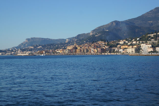
As a round-trip from Nice, this hiking day trip took us 7 hours, but a more relaxing 8 or 9 would have been preferable had we gotten up earlier. The first step is to get from Nice to Menton. There are two options for this journey, bus or train. The bus (number 100) takes about an hour and a half and costs €1.50. The train takes 37 minutes, costs €5.30 and runs every half an hour. We chose the train as we were running late.
After a beautiful train journey along the coast, we reached Menton where we caught a bus to Sainte-Agnés. Had we been more energetic, we could have walked the two hours up to the trail, but one too many days on the beach had made us lazy. Bus number 10 costs €1.50 and passes in front of the railway station every two hours on its way to Sainte-Agnés. Luckily, we had somehow managed to get the timing right and only waited ten minutes. The bus is small so it can navigate the tight curves that give way to fantastic views on its way up to the tiny mountain village where we would start our hike.
Sainte-Agnés
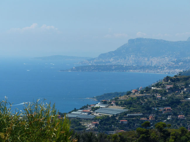
With tiny cobblestone lanes and freshly painted blue shutters against a backdrop of mountains and coastline, Sainte-Agnés made a picture perfect start to our GR51 trip. For a special vantage point, we headed north and up to the ruins of an old castle. The view from the high ruins stretches from the Italian border in the west to Cap Martin in the east and encompasses several 1200 meter peaks behind.
Once we had our fill of photos from the ruins and quaint Sainte-Agnés, we began our GR51 experience in earnest, following the clear markings. Red stripe over white stripe and we were going the right way. Red and white cross and we were about to go down the wrong path. The correct path led us down out of town utilizing an old herd path. We scrambled down the cobblestone steps, past beautifully restored villas, eager to begin our hike.
At the bottom of town, the path meets the road near a lovely picnic area and fountain. Here we decided to feast on the picnic we packed from the Monoprix in Nice, tabbouleh and salade de carottes râpées along with fresh juice to give us some extra power for our uphill climb. As we ate, dark clouds began to move across the not-so-distant peaks. The rumblings of thunder prompted fellow hikers to warn us against continuing our walk. We probably should have listened to them (walking in the mountains during heavy rain and lightning is never a good idea!), but we were looking forward to our walk and had spent all morning reaching Sainte-Agnés. We decided to continue on anyways and ended up lucky. It never rained a drop.
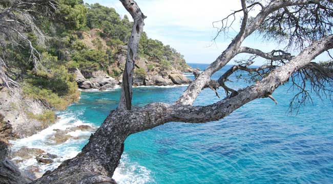
From the picnic area, the GR51 leads downhill (left on the road when facing the fountain). It continues downhill most of the way to Gorbio. For a bit of a challenge and better views, we decided to follow the PR trail between the two towns. This path is indicated by a light yellow strip. It leads up and over the peak between Sainte-Agnés and Gorbio. However, the initial ascent is not difficult, lasting only 30 minutes. It took us about 45 minutes because we had to stop to take so many photos. The views from this side of the mountain look over the gorgeous blue waters of the Cote d’Azur far below.
At the peak, the environment changes from yellow wildflowers to coniferous forest. The view changes as well. As we crossed from one side of the mountain to the other, we said goodbye to sea views and hello to mountains sprinkled with tiny French villages.
Gorbio
The wide dirt path crosses over the road and a couple of landslide areas. As always, it’s important to use caution when hiking in mountainous regions prone to landslides. But it wasn’t a tumble of rocks that gave us the biggest scare of the day. As we walked down to Gorbio, we came across an abandoned car that had obviously driven off the road and fallen down the mountain. Hesitantly, we checked to see that no one was in the car, praying we weren’t going to be the ones to make a gruesome discovery. Luckily, the crash appeared to have taken place months before and no one was left in the car.
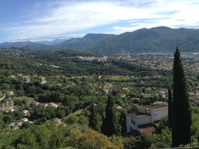
After about an hour and a half of walking steadily down the mountain through patches of dense forest, the village of Gorgio suddenly appeared on the other side of a rock face. Gorbio sits perched on a cliff just above the end of the PR trail. Here the trail once again joins the GR51 for the final climb into the village.
At the top of the hill, we passed a tiny church before arriving in Gorbio’s main square. It is from this main square that the bus leaves for Menton every two hours. This was explained to us by the locals as there is no sign telling visitors of the bus stop location or bus schedule. We still had an hour to kill before the next bus, so we set off to discover what Gorbio had to offer.
The town is small. Its tiny, uneven streets meander around a church at the town’s highest point. A hike up to the church reveals a wonderful view of the Mediterranean and the larger towns below. When we arrived at three in the afternoon, the town was all but deserted. It is not the typical tourist town of the French Riviera. This is a beautiful place where people live and commute to the larger areas for work. The peaceful town takes less than half an hour to walk around but gives visitors so much more enjoyment than nearby tourist centers. I would recommend it over Eze any day.
To rest our feet and wait for the bus, we decided to sit down at Les Terrasses, a café on the main square, for a cup of coffee. It wasn’t long before we were engaged in conversation by curious locals. Our poor French ran out rather quickly, but it was enough to know we were more than welcome in this town deserving of a larger tourist trade. Too soon, the bus arrived and we were whizzing down the curvy road back to Menton and our return train journey to Nice.